Vietnam’s Hidden Tectonic Power: Faults, Fire and Rising Mountains
High above the rice terraces and mist filled valleys of Sapa rises Mount Fansipan, the tallest peak in Vietnam. Its dramatic slopes and rugged skyline are not the product of volcanic fire, but of immense tectonic forces that reshaped Southeast Asia millions of years ago. Beneath the beauty of northern Vietnam lies the Ailao Shan Red River Fault, a vast fracture in the Earth’s crust born from the collision of continents. This deep geological engine lifted ancient rocks into the sky, fractured the mountains and created the conditions for earthquakes and natural hot springs that still define the region today.
The Ailao Shan Red River Fault, Sapa and Mount Fansipan
Northern Vietnam is home to some of the most spectacular mountain scenery in Southeast Asia. The landscapes around Sapa, the towering summit of Mount Fansipan and the scattered hot springs of Lai Châu Province all share a common origin. They are products of the Ailao Shan Red River Fault, one of the most important tectonic structures in the region.
Understanding this fault helps explain not only the dramatic topography of the Hoàng Liên Sơn range, but also the level of earthquake risk and geothermal activity found across northern Vietnam.
If you are planning a trip to the region, you may also want to read our guide to Things to Do in Sapa and our detailed overview of Northern Vietnam Travel Planning.
What Is the Ailao Shan Red River Fault?
A fault is a fracture in the Earth’s crust along which movement has occurred. That movement is caused by tectonic forces, meaning forces related to the movement and interaction of lithospheric plates. The Ailao Shan Red River Fault, often called the Song Hong Fault in Vietnam, is a major strike slip fault system that runs from eastern Tibet through Yunnan in China and into northern Vietnam before extending towards the Gulf of Tonkin. It trends roughly northwest to southeast and marks a deep zone of crustal weakness.
The fault developed during the collision between the Indian and Eurasian plates, a process that began around 50 million years ago. Between about 30 and 15 million years ago, enormous sideways movement occurred along this zone, shifting blocks of crust by hundreds of kilometres. Although movement today is much slower, the fault remains active and continues to accommodate gradual crustal deformation.
Where Does the Fault Run in Relation to Sapa?
Sapa lies within the Hoàng Liên Sơn mountain range in Lào Cai Province, near the border with China. It does not sit directly on the main strand of the Red River Fault, but it lies within the broader shear zone associated with it. This deformation belt is tens of kilometres wide and contains numerous secondary faults and fractures.
These smaller structures are important because they control both earthquake activity and groundwater flow. The wider region, including Lai Châu and Điện Biên provinces, experiences occasional moderate earthquakes, typically in the magnitude 4 to 5 range. Larger events are possible but far less common than along major global plate boundaries.
If you are considering trekking in the region, our Sapa Trekking Guide explains the terrain, elevation and landscape in more detail.
Why Are There Hot Springs Around Sapa and Lai Châu?
One of the most intriguing features of the region is the presence of hot springs in and around Sapa and across Lai Châu Province. These springs are not volcanic in origin. Instead, they are controlled by fault related hydrothermal circulation.
Rainwater from the high mountains infiltrates fractured bedrock and travels downwards along fault planes. As it descends several kilometres into the crust, temperatures increase naturally with depth. Northern Vietnam has a moderately elevated geothermal gradient due to crustal thickening during the India Asia collision. The heated water then rises back to the surface along permeable fault zones and emerges as hot springs.
This process depends on fractured rock and deep circulation, not on active magma chambers. There is no evidence of present day volcanic systems beneath Sapa.
If you are interested in experiencing the geothermal hot springs and cave networks, there are opportunities to visit these locations while on some of our multiday exclusive Motorbike Adventure Loops.

How Mount Fansipan Was Formed
At 3,143 metres, Mount Fansipan is the highest peak in Vietnam. It is not a volcano but an uplifted block of ancient metamorphic and granitic rocks that formed deep within the Earth’s crust hundreds of millions of years ago.
During the India Asia collision, parts of Southeast Asia were squeezed and displaced sideways. The Red River Fault acted as a major structural boundary that allowed crustal blocks to move and, in some areas, to rise. The Hoàng Liên Sơn range, including Fansipan, was uplifted along this tectonic system.
Over millions of years, intense monsoon rainfall, river erosion and landslides sculpted the uplifted block into the steep ridges and valleys seen today. Fansipan’s height reflects crustal thickening and tectonic uplift rather than volcanic construction.
The Wider Geological Setting of Vietnam
Vietnam lies away from a direct plate boundary. The nearest major active boundaries are the Himalayan collision zone far to the west and subduction systems beneath parts of the western Pacific. Northern Vietnam therefore experiences intraplate deformation rather than direct plate boundary activity.
This distinction is important when assessing geological risk. Intraplate faults such as the Red River system typically move more slowly and release energy less dramatically than subduction zones or major transform boundaries like those found in Japan or Indonesia.
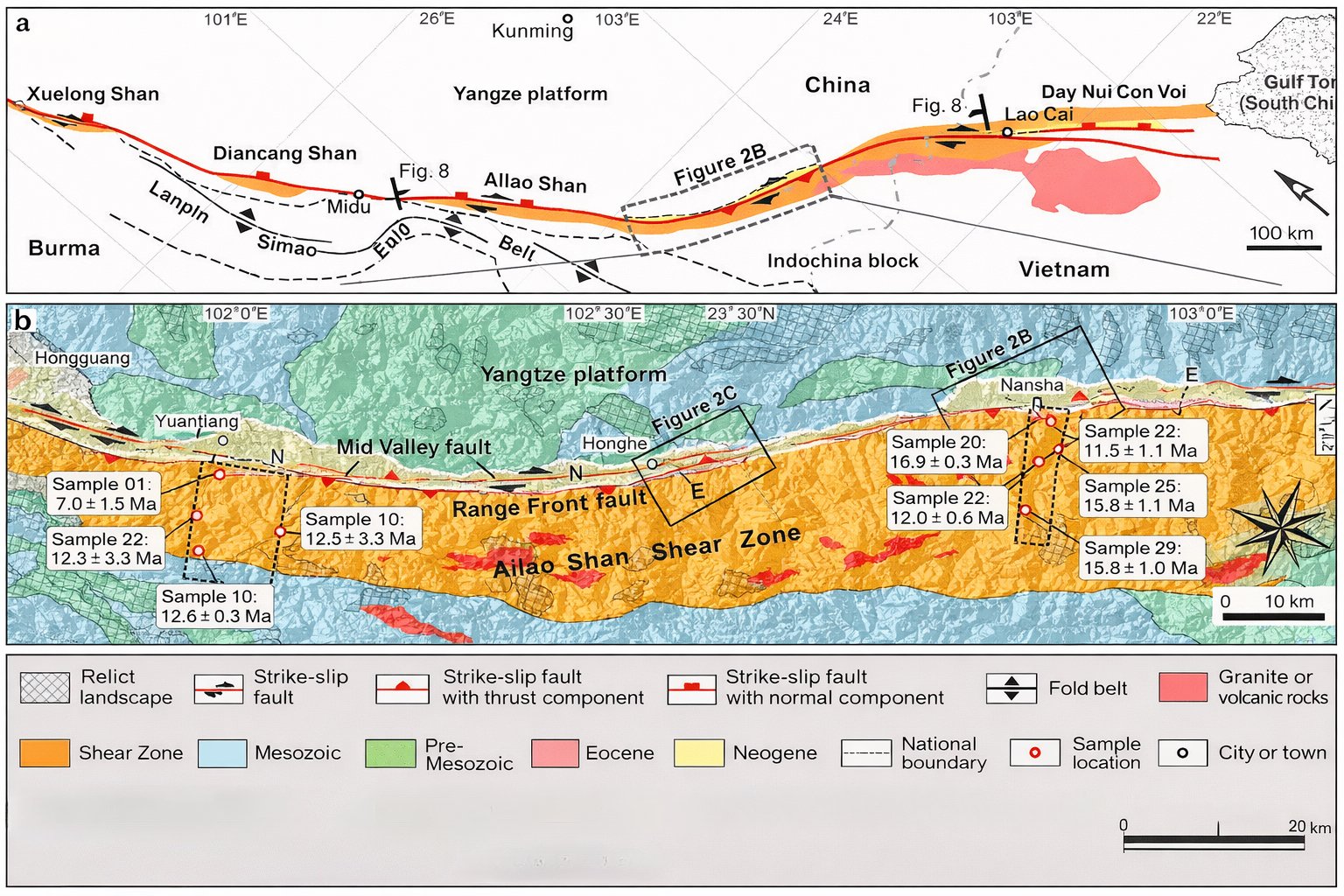
Simplified geologic map of the Ailao Shan-Red River fault (after Harrison et al. [1996] and P. L. Wang et al. [1998]).
What Risks Does the Fault Pose?
The primary geological risks in northern Vietnam are moderate earthquakes and landslides, particularly in steep mountainous terrain around Sapa and Lai Châu. While damaging earthquakes are possible, the likelihood of extremely large magnitude 8 or 9 events is far lower than in regions located directly on major plate boundaries.
Fault systems like the Ailao Shan Red River Fault are generally considered less hazardous than active subduction zones because they accumulate strain at slower rates and over broader areas. That said, they are not risk free. Infrastructure, hillside development and road networks in mountainous areas can be vulnerable to shaking and slope failure.
A Landscape Shaped by Deep Time
The mountains around Sapa, the summit of Mount Fansipan and the region’s hot springs all trace back to the same tectonic engine. The Ailao Shan Red River Fault reshaped the crust of Southeast Asia during the aftermath of the India Asia collision, uplifted ancient rocks and left behind a fractured landscape that still channels heated groundwater to the surface.
Today the region is tectonically alive but comparatively subdued. Its geology offers both natural beauty and manageable geological risk, shaped by millions of years of slow but powerful crustal movement beneath northern Vietnam.

Ready to Explore Sapa?
If this geological story has inspired you, start planning your trip today.
👉 Read our complete Sapa Travel Guide
👉 Discover the best Sapa Trekking Routes
👉 Prepare for your climb with our Mount Fansipan Hiking Guide
Understanding the landscape makes visiting it even more rewarding. Explore wisely, travel prepared and experience one of Vietnam’s most fascinating mountain regions.